WATER IN OUR ENVIRONMENT
About Surface and Groundwater
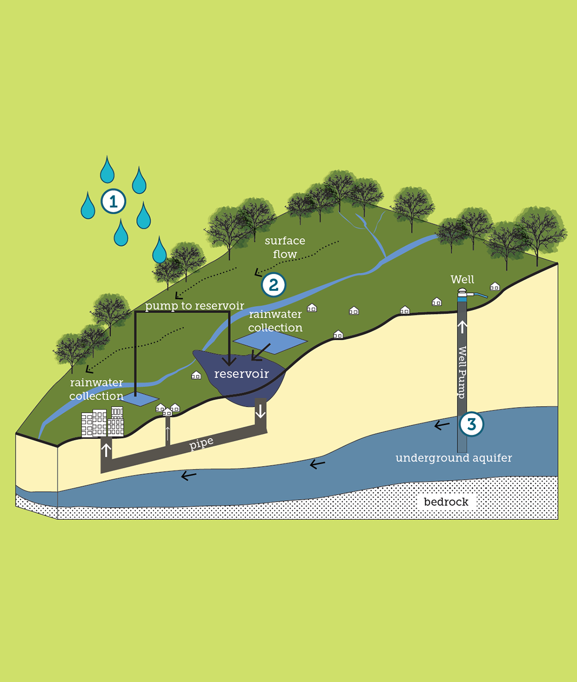
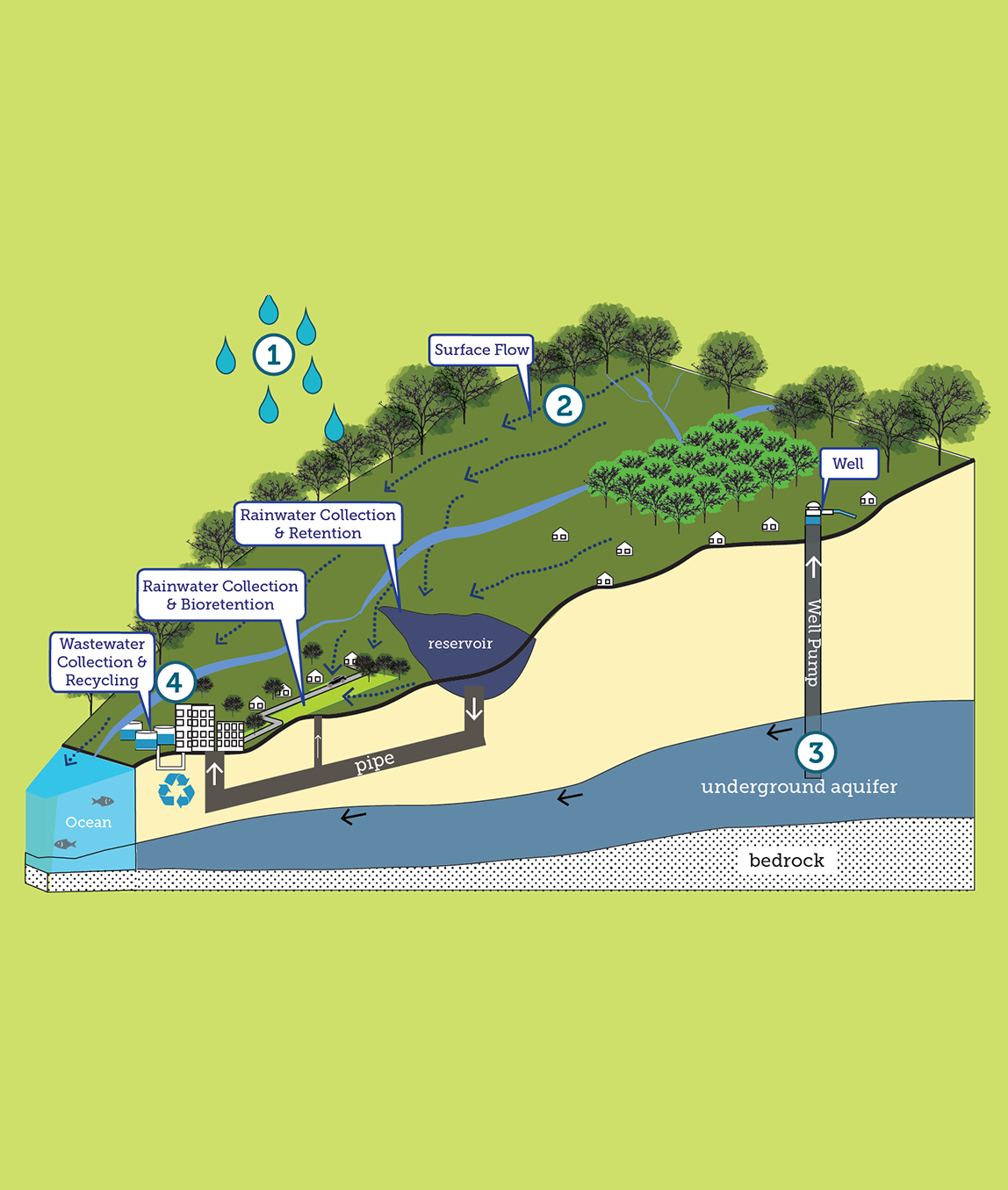
Where Does My Rainwater Go?
2. Surface water flows into rivers, streams and reservoirs.
3. Groundwater is precipitation that seeps into the earth’s soils and rock formations and stored in aquifers. Groundwater is stored in underground reservoirs known as aquifers. Water can be pumped from underground reservoirs known as aquifers using wells.
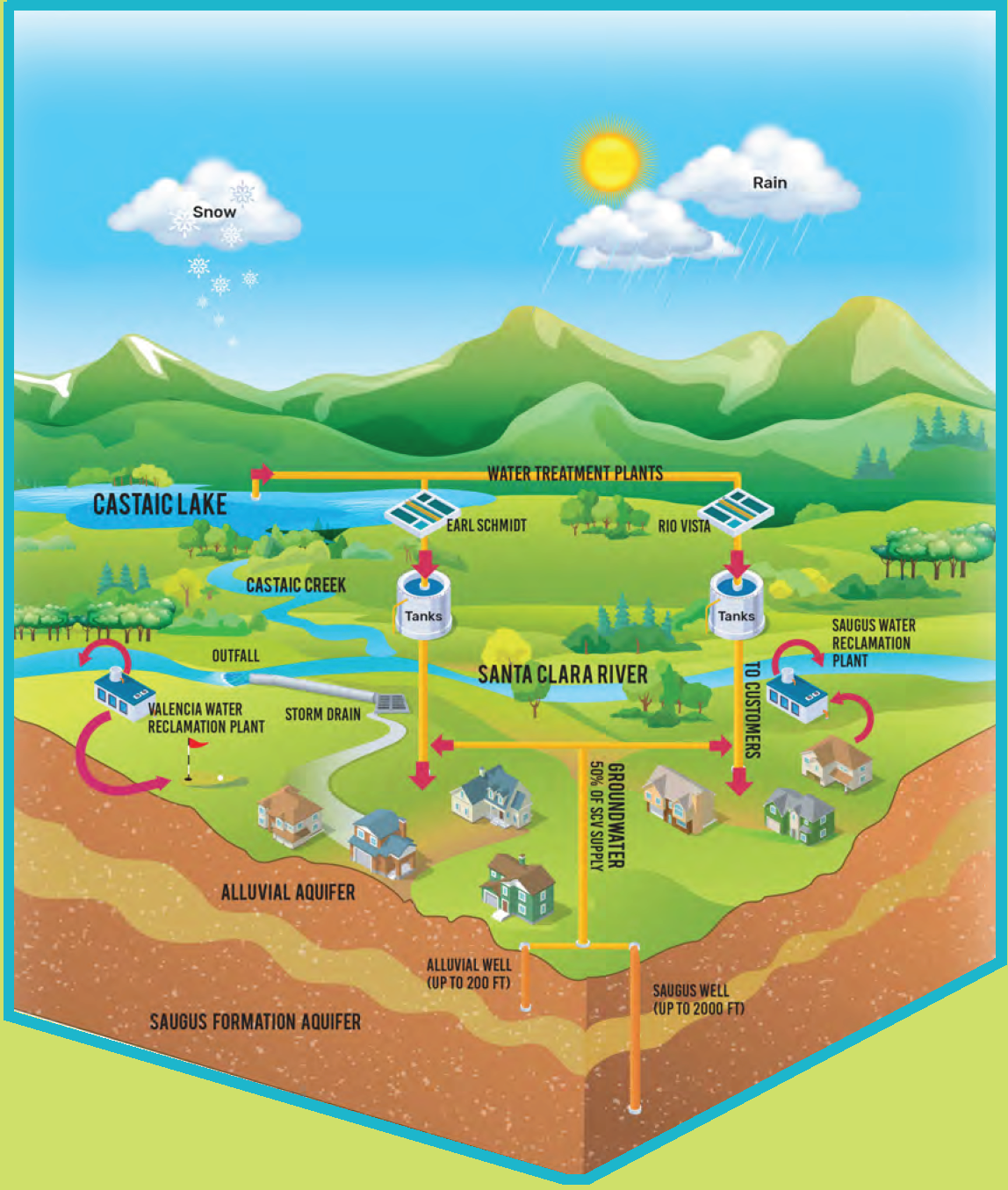
Check out what happens to rainwater in the Greater Los Angeles County, Ventura County and the Upper Santa Clara River Watershed in the diagrams to the right.
Groundwater
What is a Watershed?
A watershed is a land area that channels rainfall and snowmelt into creeks, streams, and rivers that flow into a common outlet such as reservoirs, bays, or the ocean.
Learn more about watersheds.
Watershed Map
Check out the map below to see watersheds in the area. You can also find your watershed by clicking the search button un the upper right corner and typing in your address.
About Land Use and Capturing Rainwater
Land use directly affects how water moves through communities
Land use in urban communities ranges from open space and agriculture to varying levels of development. Developed land often consists of impervious surfaces, such as asphalt and concrete.
When land is paved, water is not able to soak into the ground. Too much water flowing across the hardened landscape can result in flooding and/or erosion. Water that flows over the hardened landscape is lost to the oceans and streams when it is directed into the storm drain systems that lead directly into rivers and oceans.
This untreated water is called urban runoff. Urban runoff, carrying pollutants such as automotive fluids, trash and pesticides, is the biggest source of pollution in our rivers and ocean.
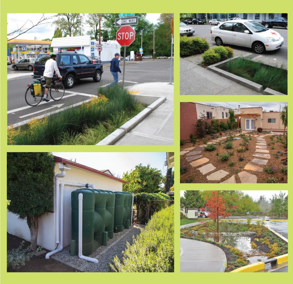
Capturing and Storing Water
Harvesting rainwater offers many benefits for communities. Capturing rainwater not only helps keep our waterways and ocean clean, but helps to replenish our groundwater supply and reduce our dependence on imported water.
Potential strategies for catching and storing water include creating rain gardens, bioswales, bioretention ponds; protecting open space; removing hardscape; and redirecting rainwater that falls on rooftops and parking lots into large tanks (cisterns) where it can be stored for later use.
These various methods function to keep our waterways and ocean clean, and help replenish our groundwater supply and reduce our dependence on imported water. Additionally, sustainable landscaping and irrigation practices can reduce and treat urban runoff while also conserving water.
Resources
Enhancing Urban Runoff Capture and Use
Prepared by the Office of Water Programs, California State University, Sacramento
Enhanced Watershed Management Plan
Prepared by Upper Santa Clara River Watershed Management Group
Coordinated Integrated Monitoring Program
Prepared by Upper Santa Clara River Watershed Management Group
How Can Water Get Contaminated?
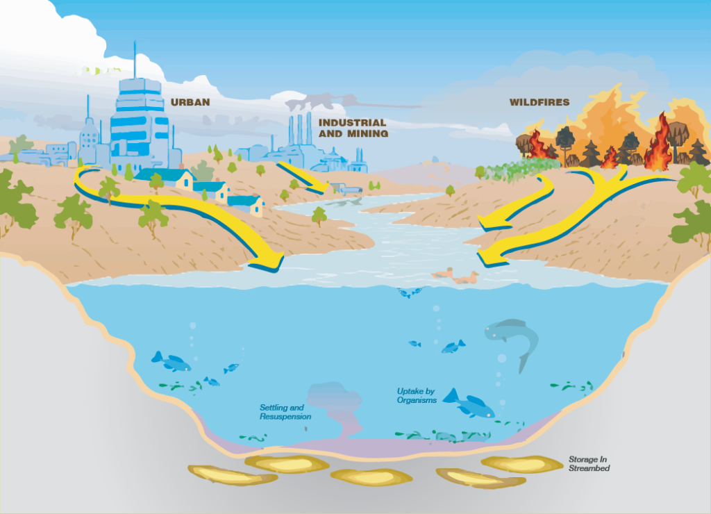
How Can Contaminants Get Into Our Water?
When land is paved, water is not able to soak into the ground. Water that flows over the hardened landscape is directed into the storm drain systems that lead directly into rivers and oceans.
This untreated water is called urban runoff. Urban runoff, carrying pollutants such as automotive fluids, trash and pesticides, is the biggest source of pollution in our rivers and ocean.
Trash, bacteria from pet waste and aging septic tanks, fecal bacteria, litter, pesticides and herbicides, dust from brake pads on cars, and many other pollutants impact our local streams, rivers, beaches, and groundwater aquifers.
Stormwater pollution can be prevented by correctly disposing chemical and material waste or by using green infrastructure practices that treat and clean our waters.
Flooding
Am I at Risk of Flooding?
The Federal Emergency Management Agency (FEMA) defines flood zones as areas with a 1% annual chance of flooding, also known as the 100-year flood. Areas moderately at risk for flooding have a 0.2% annual chance of flooding, also known as the 500-year flood.
More localized flooding may occur within and beyond FEMA flood zones, and can negatively impact communities.
Check out the interactive flood map below where you can input an address to determine if the location entered is within an area of flood hazard.
Access to Parks and Local Waterways
How Clean Are Our Lakes, Streams, Rivers, and Beaches?
Water bodies and the habitats and open space they support can provide places for recreation and respite, contributing to quality of life in our communities. Thousands of visitors swim, wade, kayak, and fish at dozens of freshwater sites. However, certain contaminants can pose a health risk to those that recreate in and eat fish from our local streams and rivers.
Before you recreate, check the most recent water quality reports available through these resources:
Greater Los Angeles County
Santa Clara River Watershed
Ventura County
Links for Recreation
Santa Clara River Watershed
Ventura County